
WHAT THE COMMUNITY SAID
During meetings with Area 3 residents and business owners, having safe and efficient access to jobs, schools and shopping centers was identified as one of the community’s biggest obstacles. Fortunately, Area 3 has a good street network that distributes traffic across multiple corridors, but some of those corridors are not safe for pedestrians or cyclists.

 Quality Streets & Public Realm

The Area 3 community voiced a desire for more pedestrian amenities, such as new sidewalks, street lights, bus shelters, crosswalks, bike lanes, and street trees. Despite the many benefits of such improvements, paying for them can be an expensive proposition. Governments must prioritize these types of improvements along with many other community needs such as fire and police protection.
Transit Options
For some residents, driving is not an option, but often transit service is not convenient between where people live and work. More transportation choices are needed, but again, the cost of providing those choices is often prohibitive.
Local Transportation Resources
- The Transportation Planning Organization (TPO)
Is responsible for prioritizing funding for State transportation projects in this area. $684 million in transportation projects were approved in 2018.
https://chcrpa.org/index.php/transportation-planning-organization/
- The Hamilton County 2010 Bicycle & Pedestrian Plan
Can be found here: https://chcrpa.org/index.php/bicycle-and-pedestrian-plan/.
You can also access the draft 2045 Regional Transportation Plan (RTP) here: https://chcrpa.org/index.php/project/2045-rtp/
- Area 3 has some of the best transit coverage in Chattanooga with 11 CARTA bus routes passing through it. http://www.carta-bus.org/alt-flash/routes.php
- New sidewalks cost a minimum of $250,000 – $500,000 per mile. The City of Chattanooga typically can afford to build 1 -2 miles of new sidewalk per year.
Connecting Neighborhoods to Jobs and Other Destinations
One of the best ways to improve access to jobs and other destinations is to locate new, higher density housing near commercial centers. This mix of uses in close proximity provides some people with the possibility of walking or cycling to work, school or shopping. Locating higher density housing around commercial centers can also alleviate some of the concerns existing residents have about apartment buildings in the middle of their neighborhood. Concentrating commercial development and higher density housing in designated locations also improves the feasibility of future transit service.
Cities across the country are redeveloping existing buildings and vacant sites with a variety of uses to better align transportation investments and connect adjacent communities. Some of these include: Denver, Minneapolis, Charleston, Austin. Many of these redevelopment sites include a mix of two or more uses, such as:
- Clean industry
- Retail
- Multi-family housing
- Single-family housing
- Offices
- Parks
- Entertainment
- Wildlife habitats
Benefits of Mixed-Use, Walkable Communities:
Numerous studies list the benefits of walking, for both the individual and the community as a whole.
- Safety: Lower rates of traffic fatalities for both pedestrians and motorists.
- Health: Walking is the easiest way to meet the minimum guidelines for moderate physical activity.
- Social Equity: Low-income families are more reliant on walking for essential journeys.
- Environmental: Converting from driving to walking reduces air and water pollution.
- Transportation: One quarter of all trips are 1 mile or less. Increasing walking reduces traffic congestion and road maintenance costs.
Elements of Street Character
Cityscapes I is an interesting study, sponsored by the Chattanooga Design Studio that illustrates our city’s corridors as its connective tissue.
See www.chattanoogastudio.com/projects for the full report.

Example Images
 Designated bike lanes provide safety for cyclists.
 Walkable streets often have sidewalks and street trees.
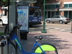
 Fast and frequent transit service requires density.
") Safe sidewalks mean some children can walk to school.
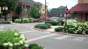
Safe sidewalks mean some children can walk to school. Streetscape can enhance key gateways and corridors.
TRANSPORTATION: CONCLUSION
While cars are certainly the primary mode of transportation for most people, there are many who cannot drive for various reasons and others who just prefer not to drive. We need to provide viable transportation choices for everyone. Area 3 has a good start with its network of streets and multiple transit routes, but we can do more.
-1")
Survey Time!
Click the button below to begin the survey.
Questions?
Please contact Pam Glaser, Principal Planner, at pglaser@chattanooga.gov or call 423-643-5911.